
The valuation platform for county assessors
Every step of a reappraisal, staged before it's real.
Revaluator is the valuation platform counties run a reappraisal on: assign the work, collect it in the field with GPS and imagery, correct the property record and sketch, review it in the office, and defend the values with real sales evidence — all in a staging copy of your data. Nothing touches your live CAMA system until you say so.
Or call (854) 600-7111 — you'll reach the people who build it.
The problem
A revaluation is a deadline you cannot move.
Every parcel in the county has to be looked at, verified, photographed and priced — on a statutory cycle, with the staff you have. The work itself isn't the hard part. Keeping track of it is.
Work goes missing
Printed cards, spreadsheets and a shared drive. Nobody can say with confidence which parcels are done, which were refused, and which nobody has driven to yet.
Data gets keyed twice
Notes written in the field get re-typed into the CAMA system weeks later, by someone who wasn't there. Every hop is a chance to introduce an error.
The same trip, again
A question comes up in review and the only way to answer it is to send somebody back out to the property to look at it a second time.
How it works
One platform, from assignment to a defensible value.
Think of it as a working copy of the county. Field work, record edits, sketches and valuation studies all happen here, with a full change log, and go back to the system of record only after review.
Plan & assign
Load county shapefiles, parcel data and your CAMA extract, then group parcels into bundles and hand them to a field user as a defined work packet.
Collect in the field
Navigate by map, mark up the card, photograph the structure from your phone, capture GPS video from the road. Offline when there's no signal.
Correct the record
Change the structure, the sketch, the grade or the condition on the property record itself — against your county's own code tables, with every change logged and reviewed.
Value and defend
Scored comparables, IAAO ratio studies, sales-chasing tests and a land sandbox turn the field work into values you can stand behind at the board.
In the field
Everything the appraiser needs, on one screen.
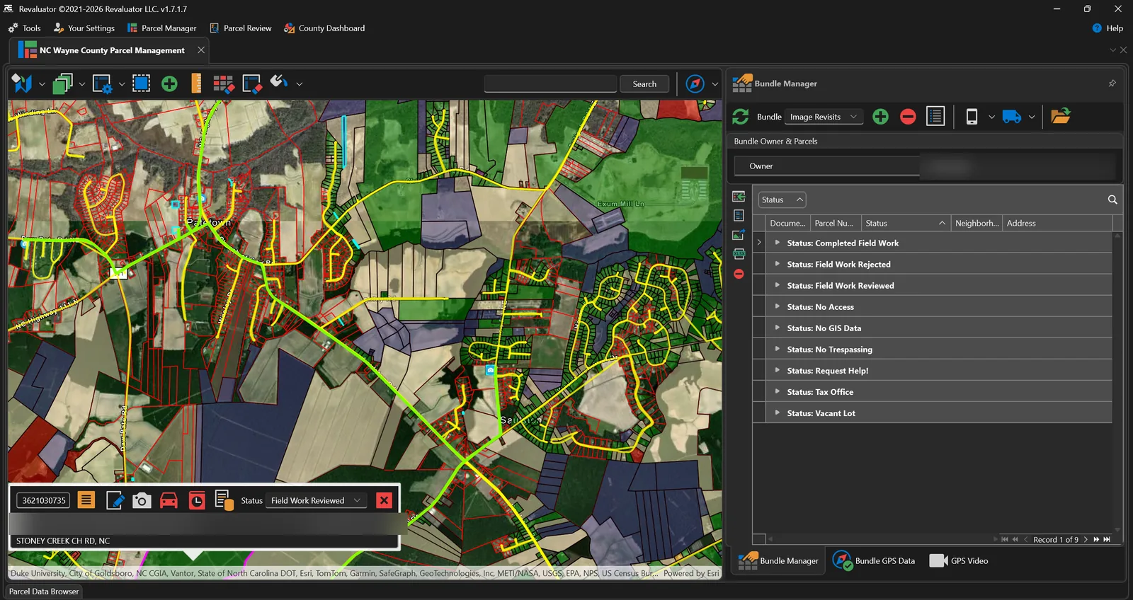
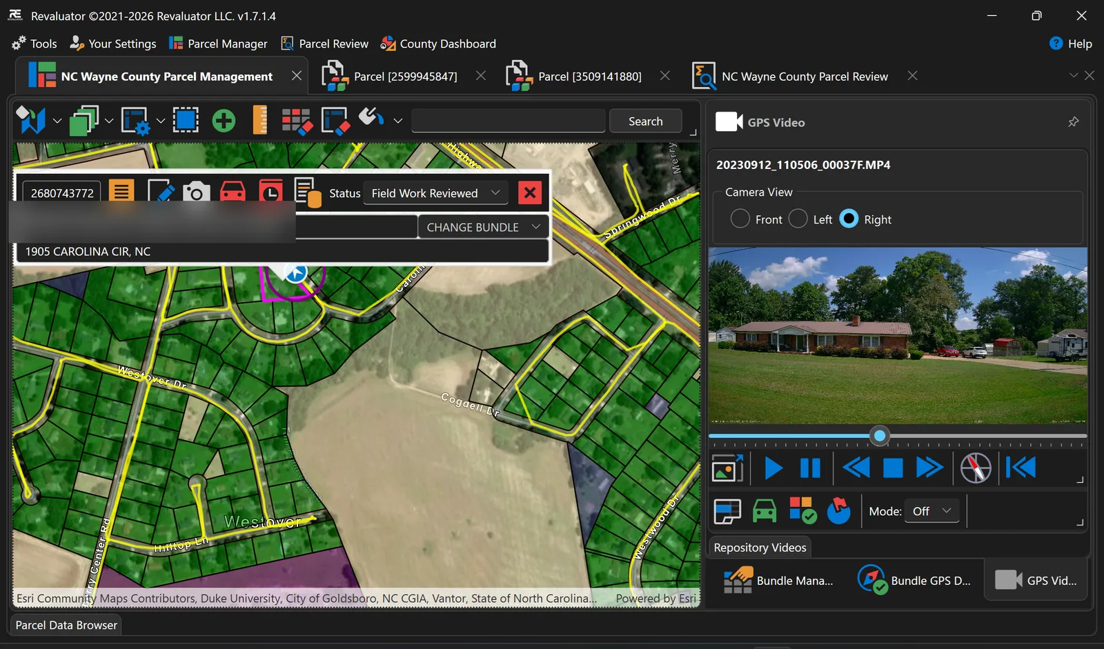
The parcel workspace puts the GIS map, the current bundle and the parcel record side by side. Parcels are coloured by status and every visited parcel carries its photo marker, so a crew can see at a glance what is finished, what was refused access, and what is still open.
- Parcel search, selection and map-geometry tools
- Status maps per work category, layer control and basemap switching
- GPS follow, breadcrumb trails and turn-by-turn routing
- Work offline, then check work back in when you have signal
The property record
Fix the record, not a copy of it.
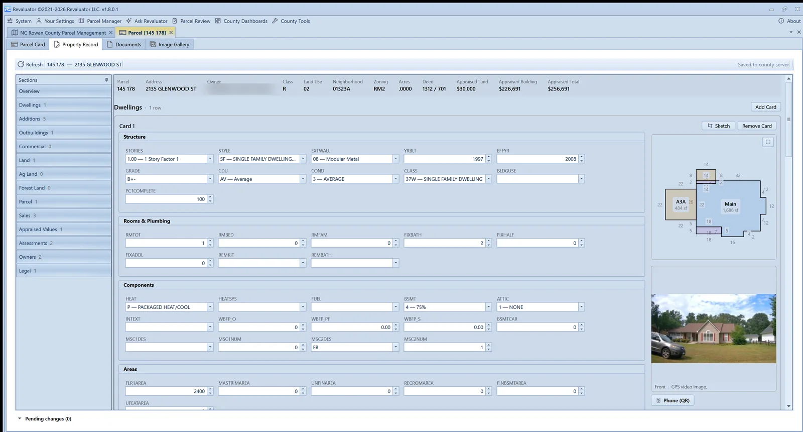
Where the CAMA system publishes a full extract, Revaluator opens the property record itself — dwellings, additions, outbuildings, commercial sections, land — with the county's own code tables behind every dropdown. Change a grade, add a card, redraw a sketch. Every edit is logged, checked, and reviewed before it goes anywhere.
- Structure, rooms, components and areas edited in place
- Sketch editor that reads and writes the CAMA's own sketch vectors
- Field checks learned from your own data: codes, ranges, types
- Approve or reject each change line by line in Parcel Review
Ask Revaluator
An assistant that works the same screens you do.
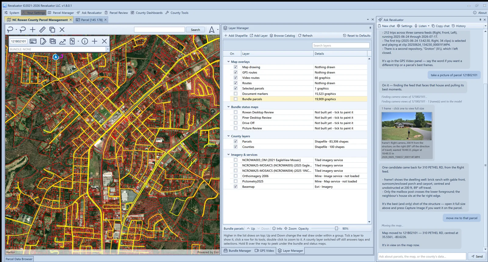
Ask in plain English and it does the work inside the app: finds parcels, lassos a neighbourhood, pulls the best video frame of a house, runs comps, edits a record under the same rules you're held to. It has only the rights your role has, it never touches live data, it asks before anything destructive — and a county can switch it off entirely.
- Parcel, sales and CAMA lookups across the county's own data
- Map, bundle, layer and video tools driven by conversation
- Record edits validated and logged exactly like a hand edit
- Voice input, chat history, and a permission set that follows your role
Back at the office
See where the reappraisal actually stands.
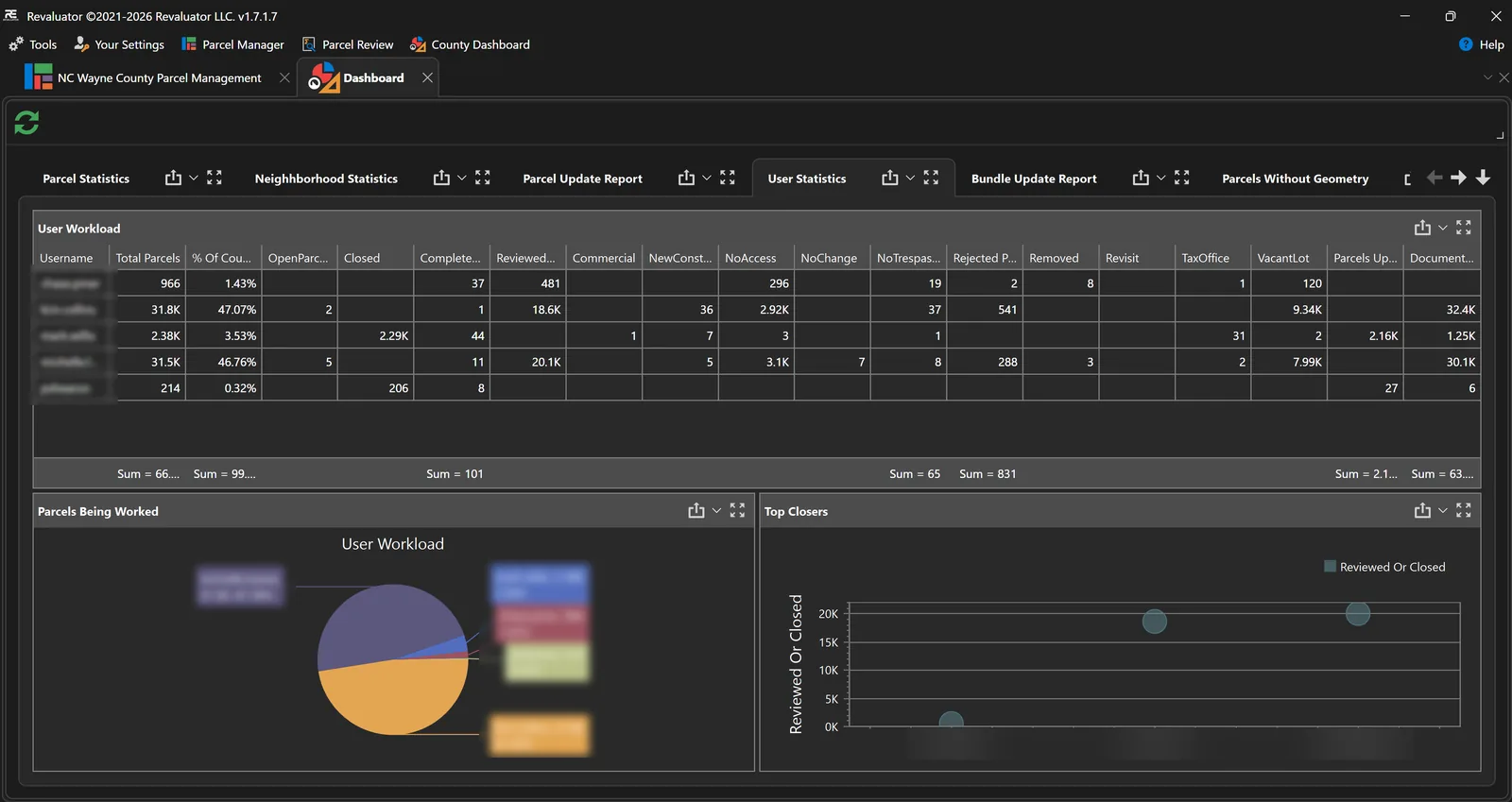
Dashboards report parcels worked, status changes, images added and card markups per user per day, so a supervisor can answer “are we going to make it?” with a number instead of a guess.
- Daily productivity by user: parcels, images, markups, hours
- Parcel, neighbourhood and bundle progress reporting
- Exception lists — parcels without geometry, rejected work
- A report designer for county-specific printouts and exports
Capabilities
What's in the box.
GIS parcel navigation
Shapefile import, status maps, parcel fill styling, measurement and map-geometry selection.
Layer manager & catalog
One grid for every layer on the map, plus a catalog of your state and county GIS portals to add layers from — linked live or downloaded for offline.
Bundling & assignment
Group parcels into work packets by category, assign them, import parcel lists and export bundles to Excel.
GPS tracking & routing
Live position, follow mode, breadcrumb trails and routing, so you can show a property was actually visited.
GPS video
Vehicle-mounted capture with telemetry. Step frames, grab stills and tie them to the parcel they belong to.
Field photos from your phone
Scan a QR code on the parcel, shoot with the Revaluator Mobile app, and the photo lands on the right card by Bluetooth.
Offline mode
Check a bundle out with its parcels, data, settings and record edits, work with no signal, then check it back in.
Parcel review
Office QA by bundle and status, with record edits approved or rejected line by line.
Dashboards & reports
Productivity and status dashboards, a full parcel report on demand, and a report designer for county outputs.
Property record editing
Dwellings, additions, outbuildings, commercial sections and land edited against the county's own code tables, with field checks and a change log.
Sketch editor
Draw, reshape, bow and split walls on a touch canvas; areas and perimeters recompute and the CAMA vector string is written back.
Comparable sales
Scored comps with the arithmetic shown, time adjustment to the valuation date, printable comp sheets and appeal packs.
Ratio studies & sales chasing
IAAO statistics per neighbourhood — COD, PRD, PRB, confidence intervals — and hold-out tests that show whether the appraiser chased the sales.
Valuation sandbox
A land-abstraction workbench: freeze the improvements, solve the land from the sales, and see every parcel's tax card and sandbox side by side.
Ask Revaluator
An in-app assistant with the same tools, the same data and the same permissions as the person using it.
Parcel cards & documents
Your county's property record cards rendered in-app with markup tools, and any file type attached to the parcel.
Roles & permissions
Built-in roles or your own, one permission per feature, licence keys per user — the assistant is bound by the same rights.
CAMA integration
Deep integration where the CAMA publishes a full extract; building and image updates elsewhere — scoped per county against the system you run.
Integrations
It talks to what you already run.
Revaluator isn't a CAMA system and doesn't replace your GIS. It reads the record you already keep, collects the field work, and hands the results back to the systems your county is keeping.
CAMA systems
- Tyler Technologies
- BI-Tek CAMA
- Keystone
- Farragut
- OneTax
Sketching
- Apex Sketch
Imagery
- Piner Imagery
- EagleView
- Google Street View
GIS
- Esri ArcGIS
- State GIS portals
- County GIS servers
AI
- Language model provider
Where it runs
Deployed county by county.
Every county gets its own configuration — parcel layers, card templates, CAMA profile and business rules. These are the assessment offices Revaluator has been built for.
- Bladen, NC
- Caldwell, NC
- Caswell, NC
- Gates, NC
- Halifax, NC
- Hyde, NC
- Lee, NC
- Martin, NC
- Nash, NC
- New Hanover, NC
- Onslow, NC
- Perquimans, NC
- Richmond, NC
- Rockingham, NC
- Rowan, NC
- Sampson, NC
- Scotland, NC
- Washington, NC
- Wayne, NC
- Wilson, NC
- Groton, CT
Common questions
Before you get in touch.
What is Revaluator?
Revaluator is software for county property revaluation and reappraisal work. It gives field staff a GIS map, assigned parcel bundles, phone and GPS video capture, and parcel card markup; gives the office review queues, dashboards and property record editing; and gives the appraiser comparable sales, ratio studies and a valuation sandbox built on the county's own data.
Does Revaluator work without an internet connection?
Yes. Field users check a bundle out to a local copy — parcels, data, county settings, downloaded map layers and pending record edits — and keep working in areas with no coverage. Everything is checked back in when the device is online again.
Which CAMA systems does Revaluator integrate with?
Revaluator works with any CAMA provider. Where the system publishes a full extract, the integration goes deep — it reads the county's record, prices every component the way the county does, and edits the property record and sketch against the county's own code tables; elsewhere it exchanges building and image updates on a schedule. Either way it sits alongside your CAMA system rather than replacing it. See the systems we connect to.
Does Revaluator write to our live CAMA data?
No. Revaluator works on a staging copy — the county's extract, its own parcel and field-work tables, its own edit log. Record changes are validated, highlighted and reviewed line by line, and only approved changes are ever handed back to the system of record, through an integration your county controls.
What is Ask Revaluator, and is it safe?
An assistant built into the desktop app. It uses the same tools the buttons use — map selection, bundles, layers, video, comps, the sandbox, record edits — so it can do real work; it is bound by the same permissions as the person signed in, it works on the same staging data as everything else, and it can be disabled for a role or for the whole county. More on the assistant.
Can Revaluator import our GIS and parcel data?
Yes. Revaluator imports county shapefiles, parcel data and parcel cards, and its layer catalog can add layers straight from your county GIS server, your state's GIS portal or ArcGIS Online — linked live or downloaded for offline use.
What does Revaluator run on?
The main application runs on Windows desktops and field tablets, with the Revaluator Mobile companion for Android phones handling field photos.
Also from our team
Need the field work done for you?
Piner Appraisal
Appraisal services for counties that need experienced people on the ground, not just the software to manage them.
Piner Imagery
Street-level imagery capture for assessment work — the crews and vehicles that drive the routes feeding Revaluator's GPS video system.
Got a revaluation coming up?
Tell us about your county and your timeline. We'll show you how Revaluator would handle it — with your own parcel data, not a canned demo.